Overview
Comprehensive Environmental Inc. (CEI) is excited to offer drone survey & LIDAR services using small Unmanned Aerial Systems (sUAS) platforms, sometimes referred to as drones. This new service combines the use of customized real time imagery with CEI’s engineering and scientific expertise to provide superior access, timely site reviews and increased data precision. CEI's in-house pilots are certified by the Federal Aviation Administration (FAA) and fully insured for sUAS flights wherever you need them. Our pilots also are trained civil or environmental engineers or environmental scientists with the knowledge to help your projects succeed. As a fully certified small woman owned business (WBE), CEI can help you meet your set aside needs.
How it Works
CEI’s pilots will confirm that they can legally fly a given site and that the weather forecast is favorable before beginning the survey. Once airborne, the sUAS can collect LIDAR video footage and still photographic images of the area to be surveyed. The survey area can be on the ground, or it can be of an above-ground structure such as a water tower or a building. Spatial accuracy is double-checked and ensured by the use of several ground-control points or targets on the ground, visible in the sUAS photos, at known locations.
The photographic imagery is processed using state-of-the-art software that creates a two-dimensional mosaic of all the still photographs and reconstructs a detailed, three-dimensional model of the area or structure surveyed. The software can then derive contours and a bare-earth surface from these products and perform accurate measurements of distance, area, and volume. The repeatability of the pre-programmed sUAS flight path allows identical, repeated surveys of the same area over time, ideal for monitoring progress on construction sites, changing flow patterns in streams, or any other time-based variable.
video inspections
specifications
As the sUAS flies its survey, it records real-time high-definition video footage of the study area or the structure to be inspected. It will fly anywhere between 50 and 200 feet above ground and can approach within a few feet of the structure, if conditions allow. The camera angle can point straight down, or in any direction between down and horizontal. Upward-looking footage is not possible at this time. Videos can be up to 20 minutes long and are generally produced in MP4 format.
SOFTWARE USE
orthophotos
When the sUAS flies a survey to recover straight downward-looking imagery, it records the images at a ground-sampling distance (resolution) of <1 inch to 2 inches depending on the flight altitude, which will usually be between 50 and 200 feet. The post-processing software uses a combination of spatial fixes, matching tie points, and color matching to merge the photographs together seamlessly into a single orthophoto mosaic. During the post-processing phase this mosaic can be further edited to sharpen specific areas, as needed. The orthophoto mosaic is a 2D layer and is produced as a geographically referenced geotiff file, suitable for use in GIS or CAD programs or in Google Earth.
Distance, Area & Volume Measurements
The data collected by the sUAS are geospatially accurate in three dimensions. This means that we can measure lengths and distances not only "as the crow flies", but also taking into account the elevation differences between the end points. Area calculations can be made for non-planar as well as planar areas. Volume measurements are also made possible by the 3D nature of the data, so that stockpiles, excavations, embankment subsidence, sediment accumulations, or any other volumetric change can be accurately measured.
GIS
The postprocessing sequence includes development of two 3D models from the spatial data collected by the sUAS. First, a surface model is created which reconstructs the survey area exactly as the sUAS recorded it, including rooftops, vehicles, fence posts, etc. The resolution of this surface is the same as the original imagery. Then, if required, a bare-earth terrain model can be derived from the surface by removing the above-ground objects such as buildings and vehicles. The resolution of this bare-earth model is five times the original ground sampling distance, or about 4.5 to 10 inches. The 3D models are created as geographically referenced geotiff files and are GIS compatible. Contours can be derived from either of these 3D models, at the resolution of the model they are made from, and can be exported in GIS shapefile format.
AutoCAD
The orthophoto mosaic can be imported into AutoCAD for use with all of your existing CAD data. The postprocessing of the sUAS images also yields a 3D surface model and a 3D bare-earth terrain model, as described above, from which contours can be derived in .dxf format. Additionally, a 3D textured mesh can also be exported in .dxf format for use in AutoCAD.
GeoHECRAS
The very high resolution of the sUAS imagery in the context of GeoHecRas dramatically increases the accuracy of stream flow calculations. They allow the development of more accurate and detailed stream cross-sections, bank elevations and configurations. These cross-sections and elevations can be exported in shapefile format for use in GIS or AutoCAD.
PROJECTS
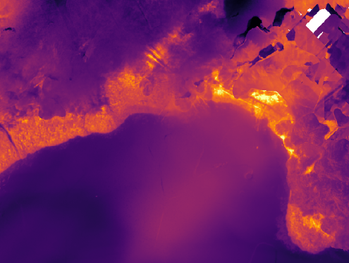
Pennichuck Water Supply Ponds – Thermal and Topographic Mapping (Nashua/Merrimack, NH)
On behalf of Pennichuck Water, CEI performed topographic survey and thermal imaging by sUAS for the perimeter of three water supply ponds in the Pennichuck system: Supply Pond (18 acres), Harris Pond (83 acres), and Bowers Pond (94 acres). Topographic/bathymetric survey data was used to refine and provide improved detail to the pond depth contours. This survey took advantage of the 2020 drought conditions and low water level that allowed for detailed sUAS survey in near-shore areas that are typically under water. Thermal imaging using a thermal infrared camera was also conducted around the exposed perimeter and shallow near-shore area of the ponds, to detect areas with relative temperature differences associated with groundwater seeps.
Wachusett Reservoir Stormwater BMPs
On behalf of the Massachusetts Department of Conservation and Recreation, CEI conducted an sUAS assessment of stormwater best management practices (BMPs) draining to Wachusett Reservoir in West Boylston, MA. High-resolution sUAS imagery supported assessment of the condition and maintenance requirements for a variety of structural BMP features, including culvert and headwall conditions, areas of erosion, sediment deposition and volumes, vegetative cover, etc. sUAS imagery was also used to provide detailed site topography.
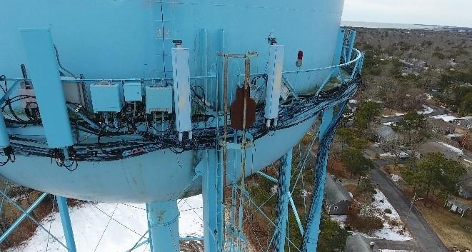
Dennis (MA) Water Tower
This project involved the replacement of an existing water storage tank with a new 1,000,000-gallon composite storage tank. An inspection of the old tank was required, which CEI conducted using a sUAS platform to perform the inspection safely from the ground and at significant time savings. Despite a challenging interference environment due to the presence of cellular service antennas installed on top the tank, the sUAS performed the inspection safely and reliably.
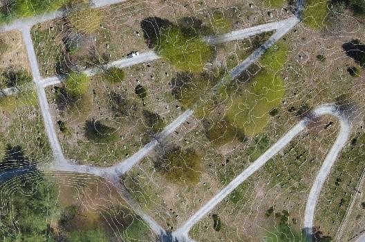
Pine Grove Cemetery (Salem, NH)
The City of Salem selected CEI to conduct high-resolution imagery and topographical surveys of Pine Grove Cemetery for use by the City’s engineering department and eventual integration into their web-based GIS portal system. Survey-grade control points were established across the 40-acre site to achieve and verify vertical and horizontal accuracies of less than 2 inches. Due to the sanctity of the location, CEI followed procedures established to ensure that cemetery visitors were not disturbed by the work and that no ceremonies would be impacted in any way. Work at the site was completed in approximately 3 hours.
Pennichuck Water Supply Pond Assessments(NH)
On behalf of Pennichuck Water Works, CEI conducted an sUAS assessment of water supply ponds that supply Nashua and ten surrounding municipalities in southern New Hampshire. The assessment included high resolution imagery to determine areas of shoreline erosion, sediment deposition, extent of emergent and floating aquatic vegetation such as water lilies, and condition of stormwater management infrastructure draining directly to the ponds. The imagery was also used to document the presence and extent of an ongoing cyanobacteria bloom within a portion of the pond complex.
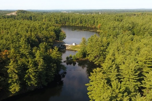
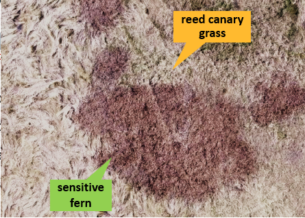
Mill River Watershed - Wetland Restoration Model Verification and Ground Truthing
CEI conducted investigations to prioritize sites for wetland restoration within the Mill River watershed. This project included site screening using the Duck-Pensaukee model. CEI further prioritized sites through GIS analyses and field investigations of soils, vegetation, connectivity to existing wetlands, and other criteria. High-resolution remote sensing imagery and topography was obtained via sUAS to support detailed vegetation mapping and wetland restoration plans.
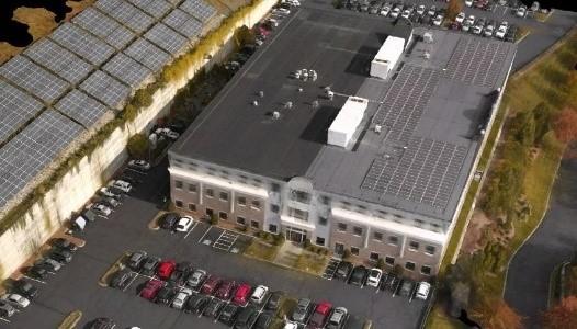
Marlborough (MA) Office Building
CEI conducted an sUAS survey of a large office building, its surrounding parking lots, and associated solar panel array to develop a 3D reconstruction of vertical and inclined surfaces. During postprocessing, the point cloud was edited to constrain the flat surfaces and remove noise. Ground control points were used to confirm vertical accuracy. The resulting model is an example of successful 3D reconstruction of a built environment.
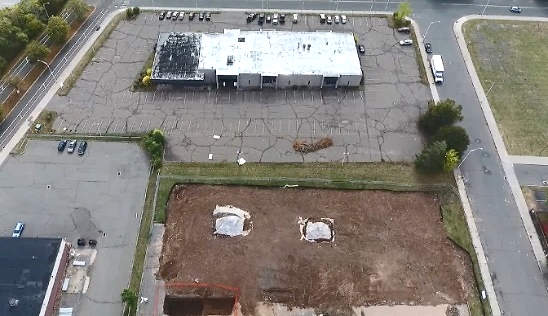
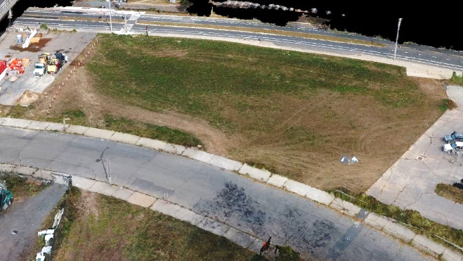
New Britain (CT) Brownfields Area Redevelopment
Aerial sUAS imagery was provided to graphically depict this multi-acre planning area and its proximity to the Connecticut FastTrack guideway and stations. The area features historic industrial buildings that were once served by the railroad which has now been converted into a dedicated busway commuter line. As part of a CT-DECD grant, CEI and its partner will be using this information in developing a reuse plan and identifying areas for environmental site remediation.
MassDOT Stormwater BMP Inspections via sUAS
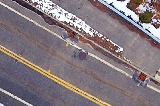
CEI worked with the MassDOT Highway Division to inspect stormwater BMPs using Small Unmanned Aerial Systems (sUAS). The sUAS technology efficiently collects data on existing conditions of above-grade stormwater management BMPs. This information was used to identify physical conditions affecting BMP performance and inform BMP maintenance needs. CEI’s licensed pilots conducted a series of flights over stormwater BMPs to collect video and ground data. This information was analyzed by CEI’s civil engineers to support development of BMP management and maintenance recommendations.
Whitesbridge Wellfields (New Britain, CT)
For the New Britain Water Department, CEI conducted an sUAS flyover of the extensive Whitesbridge wellfields. The wellfields include a southerly wellfield which features two pump stations and 23 wells along a recharge canal. The northern wellfield features six tubular wells and a pump station. The sUAS flyover provided high-resolution imagery for the department operators and will also be used to supplement detailed mapping for floodplain analysis.
police Department Redevelopment (New Britain, CT)
CEI served as the engineer of record and Licensed Environmental Professional (LEP) of record for building remediation and demolition of the former New Britain Police Department building. As part of the work, CEI prepared sUAS orthophoto images and visual flyover for marketing to potential developers. In addition, survey grade mapping via sUAS was used to confirm as-built conditions upon completion of demolition and site restitution activities.
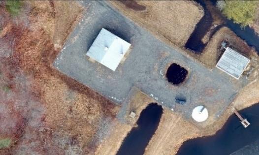
kingston (MA) Water Treatment Plant
A water treatment facility was surveyed to map site topography, retention ponds and connections to the water distribution system. Despite partial snow cover at the time of survey, the postprocessing algorithm was able to create an accurate photomosaic. Snow cover, including in the dry retention pond, was not sufficient to influence the topographic surface. The elevations, details and condition of the facility are clear and easy to compare with as-builts of the site.
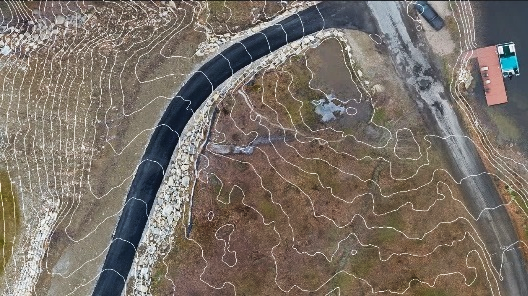
Sutton (MA) Culvert Flood Mitigation
A newly constructed driveway created a low area near its intersection with the road. This low spot would occasionally flood, requiring the installation of a culvert to convey water to a lake on the other side of the road. CEI surveyed the site by sUAS and developed an accurate, high-resolution topographic model with 1-foot contours. The model surface and contours now support informed decisions by geotechnical engineers for the appropriate placement and capacity of the culvert.
water Supply sUAS Video Services (Griswald, CT)
CEI provided video flyover services via small Unmanned Aerial Systems (sUAS) for a system of water supply reservoirs and tanks in Griswald, CT that are managed by the Hazardville Water Company. sUAS services for this project included water tank inspection according to an approved protocol and development of detailed video imagery for areas of concern throughout the watershed.
FOREST ID (LAKE MASSABESIC WATERSHED, NH)
On behalf of Manchester Water Works, CEI is conducting a project in the Lake Massabesic water supply watershed using Forest Investigations by Drone (ForestID). ForestID efficiently collects high-resolution imagery and data to assess forest health, using specialized cameras to create Normalized Difference Vegetation Index (NDVI) imagery. NDVI combines near infrared wavelengths and portions of the visible light spectrum to produce images tailored for broad-scale, rapid assessment of forest health and signs of potential stress from parasites, insects, drought, road salt, etc. This project is focusing on identification of potential insect and pathogen stressors including the emerald ash borer, Canavirgella needle cast, and Caliciopsispinea. This project is funded with a Source Water Protection Grant from the New Hampshire Department of Environmental Services.
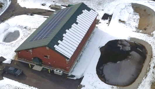
Water Storage Tank Inspections
CEI’s drone services provide an additional tool for water storage tank inspection. Images and video taken using the drone exceed those obtainable from ground level. The drone provides the ability to capture a full 360 degrees around the tank and views from above the tank, at vantages not seen before. The drone can be used to complete annual tank inspections without the need for climbing the tank. Additionally, images from the drone can be used for planning and scheduling of a thorough inspection that would require someone to climb the tank for a closer look at tank finishes, rust or pits, vents and other features.
Watershed Security, Evaluation & Monitoring
Scheduled aerial views of large managed areas such as protected watersheds, conservation parcels, parks, trails and easements help owners and supervisors better manage property. CEI can inventory and evaluate property that may be too large or difficult to access on a regular basis. We can work with you and your staff to identify and monitor areas that may need more frequent inspection. This may include assessment of trends in sedimentation, erosion, invasive species, land use concerns or security issues that might need addressing in future management efforts.
Aboveground Asset Management & Horizontal Pathways
Take your asset management and Capital Improvement Plan to the next level with cost-effective mobile mapping that can capture visible aboveground assets with a wide degree of image coverage. Aerial imagery can help to eliminate ground impacts such as traffic control and safety hazards. Similarly, CEI can develop essential preliminary pathways for underground utilities, roadways and other horizontal pipelines. Unlike other services, CEI not only provides the flight services but combines it with experienced civil engineers who can expertly process collected data for real world use.
Disaster Preparedness & Post Disaster Forensics
Vital for all public entities ranging from utility suppliers to first responders to facility managers, pre-disaster planning is vital to municipal emergency preparedness. CEI can assist with both community wide planning efforts and post-recovery tasks. These may include: vulnerability assessment, repetitive loss analysis, aid prioritization, landscape change mapping, debris quantification and erosion/sedimentation mapping and impact analysis.
Construction Inspection & Progress Photodocumentation
Construction reporting is often a large component of permit compliance at local, state and federal levels. Using drones to increase construction inspection frequency and reliability can help keep costs low while providing a more comprehensive look at active and seasonally inactive sites. Construction progress photodocumentation can be a valuable component to project development and an essential visual tool when providing updates to local stakeholders. Generally obtained at major milestones throughout the construction progress, photodocumentation with an sUAS is significantly more cost-effective than a manned flyover or on the ground inspections and can be completed on a more regular basis providing a fuller picture of project progress.
Natural Resource Inventory & Analysis
CEI can collect spatial data and imagery of large areas making it ideal for natural resource inventories. These may include coastal resource analysis, forestry management planning and hydrologic resource mapping. Data can be collected in a much shorter timeframe and be used to identify problem areas, short and long-term changes, site specific problems such as beaver dams and other blockages, and overall landscape changes that may impact downstream resources and long-term management decisions.
